


 N 34°03'29''
W 84°27'44''
The odyssey home has been a little adventure on its own. The journey has actually been comparable to the excitement and passion of the being in Alaska itself. The begin and end of the transcontinental expedition is practically not worth mentioning when you taken in account of the new scenery of west Alberta, Montana, Wyoming and southwest South Dakota. This is my odyssey home…
The first thing to mention is that the original timetable for the trek quickly went out the window. On the first day, we quickly hit our goal of reaching Whitehorse, Yukon in roughly 13 hours, and we decided to stay in a campsite just outside of town at the ripe old hour of 11pm Pacific Time. Day 2 turned out to be considerably longer stretch than originally planned (this is wear we began to stray and did not stop). That morning from Whitehorse, Yukon, we awoke just after 6am broke camp with much hast. Our goal was Fort Nelson, British Columbia, but between making good time and the early start, we reached Fort Nelson just after 6pm with plenty of daylight to spare. So instead of calling an early night, we pushed on until we reached the starting point of the Alaska Highway, Dawson Creek, British Columbia. We rolled in just before midnight and stayed in a parking lot next to Mile “0” RV Campground. The morning of Day 3, we also wanted another early start. This time we were back on the road by 6am. (Note* The reason we pushed on as far as we did was to be closer to Jasper, Alberta which is widely considered in Canada to be the most beautiful part of the entire country in terms of scenic driving) From Dawson Creek, we diverted from our original course that we took north two months earlier. We went south on Alberta Highway 40 to eventually dead end into Trans Canada Highway 16 with proceeds southward through Jasper and Banff National Parks, deep in the Canadian Rockies. Even in the distance on Alberta Highway 40, the jagged peaks of the Canadian Rockies reared their rock faces for a mere preview of what our eyes were about to gaze upon. At the north entrance to Jasper National Park, we were greeted by a Canadian Park Ranger in a toll booth that informed us of the 25 Loonies we were about to fork over for a 24 hour pass through the parks encompassing the beautiful Canadian Rockies. Even at the entrance, we could already tell that these peaks at the gates of Jasper were nothing quite like the ranges of the far north we had already gotten used to. Exposed rock soared into the blue Canadian skies most reaching well over 3,000 meters (almost 10,000 feet). About 40 kilometers past the north entrance to Jasper National Park, we noticed a significant number of vehicles parked on both sides of the road. This usually indicates something worth taking another picture or at least another look at. On the opposite side of the highway, a decent sized lake of blue glass lies at the base of a mountain of commanding stature. It is here in this lake that we were witnesses to a single male caribou wading through the lake at a depth that engulfed all four of his legs. A sight like that was like living inside a photograph on the cover of National Geographic. It was truly the most majestic personal experience I have had with wildlife and nature simultaneously. After that close encounter, we only had another 20 kilometers or so until we reached the town of Jasper, Alberta, which is nestled in a valley between a handful of the Canadian Rocky Mountains. At this point, I have exhausted the oil which I got changed back when I first made it into Anchorage two months prior. So we made time for an oil change at a local garage and spent some time walking around town. Jasper is almost like a Canadian Aspen in summer time. Beautiful people everywhere with lots of money, and then there is us, a small outfit of foul smelling, rough looking guys making their way from Alaska to Georgia. We fit right in. After taking in some of the local culture and getting the oil changed, it was time to wash up by taking a dip in a near by lake. So on a public lake beach, we washed up, the quick and dirty way, with only my loofah and some biodegradable camping soap. Afterwards, we pressed on southward into Banff National Park where literally we passed high beautiful rock mountain top, ragging waterfall, glacier, ice shelf on mountain top, and so on and so forth. The cycle repeated in no particular order until we exited the Canadian Rockies, stage right.
The adventure does not stop with the departure from the Canadian Rockies. Southeast out of Banff on Trans Canada Highway 1, we went to the bustling metropolis of Calgary, Alberta. But lying on the outskirts of town was Canada Olympic Park host of the 1988 Winter Olympic Games. Upon first gaze, it seemed like an overrated Centennial Olympic Park but in Canada. This turned out to not be the case at all. Their Olympic Park was beautiful with a museum of Canadian Olympic history (with the bobsled in Cool Runnings on display), a mountain bike course set up on the former slopes of the skiing competitions, and various activities to entertain anyone for hours on end assuming you can afford it. An hour or so later, we needed to make our way through Calgary, but first, we had to check out the city. In Calgary, there is a space needle much like the one in Seattle, Washington but not quite as big, and it is simply called the Calgary Tower. Still it is a worthwhile place to see if you have never been in Calgary. We parked on the street and walked a few blocks until we stumbled onto the Calgary Tower. We then each parted with the 13 Loonies it cost to take the over 500 foot elevator ride to the 360 degree observation deck of the tower. From this vantage point, we had an almost seamless view of the entire city and even some of the Canadian Rockies in southern Banff.
It was now time to out Canada to our rudder and make our way in northern Montana, back into the Lower 48. At the border crossing just east of Glacier National Park, we crossed the 49th Parallel with such ease that I wonder how much illicit contraband travels from Canada into the Lower 48 everyday by Americans. Anyways we proceed southbound parallel to Glacier National Park until we cut inside the park at Cut Throat Creek to a secluded campground just inside the park on the east side. We made camp 5 miles down the creek just by a meadow residing between a couple of mountains. That night we saw the furry of a lighting storm quickly approaching after sunset. It was more of a show than a danger to us, and we stayed up to watched the light show of north west Montana.
The next morning, we broke camp with much haste, and began the seemingly endless voyage across Montana, through north east Wyoming and just into South Dakota. Along I-90, we approached a National Monument that we could not just pass by and decided to stop to check the site of the famous slaughter of General Custer at his men at the Battle of the Little Bighorn.
After staying a mere 6 hours in a small campground just south of Mount Rushmore, we caught earlier morning glimpse at the under construction of the new Crazy Horse Monument and the famous Mount Rushmore. Long story short, they we much smaller than I had expected.
Now onto the Badlands of South Dakota, we took a small detour in Wall, South Dakota, the town just outside of Badlands National Park. The badlands were nothing like I have ever seen before in my entire life. Peaks of accumulated sediment made jagged silhouette on the surrounding landscape of shallow valleys and rolling plains filled with prairie dogs and bison.
And here I am sitting in the comfort of my parents house in the Lower 48 nearly ready to pass out from the heat and humidity, still getting used to the darkness of night and spending more time thinking about Alaska than ever. It was the best summer I have ever had, and I don't know if any other experience in the foreseeable future will ever measure up to it... but this does not mean I won't try. Anyways thanks for reading, and I am sure I will see all of you soon.
By the way, total picture count: 2,316


 N 60°29'04"
W 149°58'25"
Never in my entire life has time gone by with such hast. This summer has flown by at a speed that can only measured in mach numbers. The days literally turned into blurs as the Alaskan summer has transformed from subarctic tundra into a vibrant tropical forest of the Pacific Northwest. This adventure has turned out far better than I ever could have imagined. I will always remember this as my coming of age journey that set the bar and my expectations as high as the mountains surrounding me.
So for the past 2 months, I have been trying out a new first name. I have decided that for quite some time I never liked the name Kyle. As a matter of fact, whenever I would introduce myself and say "Hi, I'm Kyle" in my head it would be more like "Hi, I'm Kyle?." Basically I have come to the conclusion over the years that Kyle is not a befitting name for who I am. And earlier last semester I heard an uncommon name that I felt as if I could relate more too, and for the last couple of months, I have been going by the name Desmond for that reason. It was a little unusual at first, but now I feel more natural about it. Things are different. I love this life I have for myself now. Desmond makes more sense, so that is what I will introduce myself as now.
There are so many things to say about this summer. I almost do not even know where to begin perhaps the small simple things are the most befitting. I will always remember those times hiking alone in the woods on high alert for bears. It was at those times that if you did not have bear bells singing was a good way to let the bears know that you were coming their way. So with the vigor of a drunken karaoke singer after a Jager bomb, I serenaded the boreal forest many times with popular hits of the Beatles. I will always remember writing post cards in a fashion of Christopher McCandless, but with a GPS coordinate twist as a fancy nice touch. I will always remember the rugged lifestyle I lived in the bush of the Chugach National Forest where I set my record for most consecutive days without showering (8 days). I will always remember how it felt to be in the presence of a glacier. The cool rush that flows through you when you first see the mass of ice that is so dense it glows a soft baby or robin’s egg blue is what I will remember most. I will always remember the color and taste of the water. Glacial and snow melt water that is so cold, clean and crisp, you can best describe it as “refreshing” especially when you decided to jump in and suds up instead of paying the $1.25 for a hot shower at the Kenai Princess Lodge. I will always remember the moss that often grows on the spruce trees here. Some refer to it as witch’s hair, and these mossy locks, which are dry and fluffy, make the best natural fire starter I have ever seen. (Note* Yesterday I bought a caribou antler magnesium fire striker which I used last night to start the fire) I will never forget the moments I had alone to reflect on my surroundings on my life that I have come to love more than I could possibly imagine. I will always remember the friends I made and the people I met here. I will always remember my time on the road. Watching the biomes of North America literally transform before my eyes was a sight all on its own. There has been no greater joy in my life than the happiness I experienced in Alaska.
It is like breaking off a summer love affair, and you have had a marvelous time. Now it is regrettably time to bring that relationship to an end. You are sad to see it go, but you knew from the start that this could only be a two-month thing. But you know that you will be back.
My Alaskan adventure may be over, but another adventure is about to begin, the odyssey home. While the road ahead will be an adventure of its own, I will always look back. North, to the future that is the Alaska motto. Now it is south, to the past. I will hopefully continue to blog and take pictures along the way back. See you soon.


 N 59°36'02"
W 151°24'31"
I have recently set my own record for furthest distance from home. Homer, Alaska lies on the tail end of the Kenai Peninsula, and yesterday I woke up, hit the road with my thumb out and made it to Homer just after lunch time. This is how it went down...
I headed out with the 7:30am crew for shift change yesterday, so that I wouldn't have to make the additional hike of 1.5 miles just to reach the Sterling Highway which is almost spitting distance from the Contact Station. Soon after the pit stop at the Russian River Contact Station, I took to the highway. The Sterling Highway is a two lane highway that runs all the way to Homer, the end of the line. On the long stretches, the solid lines turn to segments to allow for the faster traffic, and this highway does not exactly have room for pedestrian on its narrow shoulder. Occasionally, perhaps every 1/2 mile to 1 mile, there is a turn off loop on the side of the road. The trick to hitchhiking is that you want to give your potential ride the opportunity to pull over without stopping traffic, so these turn off spots are essential. But the for a good 3 to 4 miles, I hiked down the road with but only a few nibbles. Nibbles are very discouraging because your hopes go sky high when they slow down or pull off, and then, they fall at terminal velocity when they continue on or turn around in the pull off (only to turn back around later down the road, I know this because I recognized the same car about 5 minutes later passing me by). That double back lateral fake out happened a couple of times. It was a buzz kill.
Anyways I reached this Fuller Lake trail head a few miles down the road, and this is where I got my first pick up. A nice couple driving a late 90's pickup truck with one of those truck bed campers on it. David and Jennifer were their names. David did work with the power companies up here during the summer and has a residence to claim, but him and his family live in Minnesota for the rest of the year. David was relatively quite, but Jennifer liked to talk it up. We exchanged the common questions. I asked them about their lives here and elsewhere, and they responded and asked me the same questions. Jennifer had a really sweet, calm Alaskan folks-ie tone of voice much like Governor Palin. They were heading to Kenai (the city) to do some dip-net fishing, so they dropped me off on the edge of the big town of Soldotna, Alaska (this is the town that we go to buy groceries and whatnot, it is 45 miles west of Cooper Landing). From the west edge of Soldotna, I hiked another 2 or 3 miles down the road until a got picked up by a teenage girl with her mother and aunt in a compact car (hey a ride is a ride). They actually passed me once and doubled back to pick me up (I thought I reconized the car), but they weren't going too far down the highway. But that stretch knocked out a good ten miles or so. Anyways I'm now in the small of town of Kasilof, Alaska, and this is where I got my final ride into Homer. A foreignor driving a Homer taxi was headed there, so he gave me a lift. He had a very heavy accent with a raspy voice and a thick tongue that muddled anything coming out of his mouth. I didn't understand much of what he said, but he didn't change me. And I did thank him for the lift.
At 2pm, I set foot in Homer, Alaska, a hundred and sixteen miles away. For someone who has never successfully hitchhiked that is a very considerable distance. I went down Pioneer Ave to check-in to the Homer Hostel, but check-in was not until 5pm so I toted my burdensome back around Homer with me for the next couple of hours. And first things first. I needed food. A lady at the Homer Chamber of Commerce recommended a small place called the Cosmic Kitchen about 5 blocks down from the Homer Hostel. That was the next destination where I achieved a small thanksgiving style of satisfaction in their Big Bang Burrito. I think I earned though. After the feast in burrito form, I began to check out the sights of mainland, downtown Homer. I made it down the street on the Homer Bypass and stumbled on to the Alaska Island and Ocean Visitor Center. The Visitor Center was run in association by U.S. Fish and Wildlife, National Wildlife Refuge System, Alaska Fish and Game and the National Oceanic and Atmosphere Administration. At first it seemed to be some kind of glorified public Alaskan aquarium, but it turned out to be a public exhibit hall on various Alaskan history relating to the state's natural resource most notably, the wildlife. It was at this very moment when I have never been further from home, a familiar face recognized me. A guy named Michael recognized me from the Russian River Campground; he had come in before a few times to the Russian River. Only a mere 116 miles away from where we know each other, and we meet again. Michael told me that he actually goes to UGA in the fall semesters only cause he considers it the only semester that is worth attending. So we shot the shit about various UGA/Athens topics (bars, Greek life, location of housing off-campus and the always fun, who do we both know). Anyways we exchanged some contact information and promised to regroup back in the Lower 48. After a little of wondering around, I stumbled into the Homer Bookstore (there might be only one), and a week or two ago, I was taking with a guy working for U.S. Fish and Wildlife about the common trees on Kenai. We eventually got to talking about identifiaction of these trees, and he suggested a book called Alaska Trees and Shrubs which was co-written by a professor he knew. When I was in the Homer Bookstore, I found this book and thumbed through it. It was a well put together guide outlining the flora of Alaska. I would have bought it had it not been $25. At this point, it was 4:40pm. Time to head back to the Hostel and take a much needed shower. After a longer than ten minute shower, I felt like nearly half a million bucks (you quite feel like the whole million up here when you shower only once a week give or take a few days). Now following the revuniation of a shower after a long day hitchhiking, I took to the streets again to make my way to the famous Homer Spit. I first took a small detour to the beach to get a few pictures, but after that it was all business. The bay is surrounded by jagged mountains covered with white powder and a handfull of glaciers visible from just about anywhere on the spit or ever Homer as long as you have a good vantage point. The long and slender peninsula is 4.5 miles from beginning to end, and from the Hostel to the start of the Spit is at least a mile. I decided to walk their after my pilgrimage to Homer eariler this morning. Probably not the bet decision, but I didn't come all the way to Homer and not see the Spit. So I hoofed the 5.5 or so out there which was a really nice walk (even better if I had more energy) that was lined with rows of Lupine in full bloom along the paved walkway adjacent to the Homer Spit Road. Even though my feet were screaming for me to stop, I pressed on towards the end of the Spit. Occasionally stopping in stores to do a little window shopping, I came across a store called the Time Bandit which is referring to the fishing vessel the Time Bandit from the popular show on the Discovery Channel, Deadliest Catch. Apparently the in the off season, this is where the Time Bandit resides, and sometimes Captain John Hillstrand is around. But he was not there when I was and neither was the Time Bandit. She was out of port, but afterwards I made my way to the most popular bar on the Spit (or even in Homer for that matter). Salty Dog Saloon is this rinky dink little bar near the end of the Spit, and it is the only place in Homer to stay up and get drunk at. No other bar stays open as late as they do, and this idea of serious drinking is comically portrayed in a bumper sticker that says "Homer - A quaint little drinking village with a fishing problem." The bar had a low ceiling with relatively narrow doorways. It was dark with tons of accumulated novelties on the walls and ceiling. Almost every inch of the entire bar was covered with pinned up $1 bills with writting on them from past visitors to the bar, usually dated with locations or insightful words written on them. And there was so many $1 bills that I literally cannot fathom even a ball park guess as to how much money is on the walls of the Salty Dog Saloon in Homer, Alaska. Anyways I came in sat down at the bar and had a couple of local brews from the Homer Brewery which were in recycled Sobe bottles with a Homer Brewery label on them. Don't know how they fanagled the copyright laws on that one, but an innovative idea none the less. With only a large burrito in my stomach from lunch and two Sobe bottle worth of Homer beer, I began to make my way back down the Spit just before midnight, but I didn't have walking in mind. I got picked up twice, and the second guy literally was driving right by the Homer Hostel.
In the morning, I awoke just after 7am to enjoy the feeling of a hot shower at the beginning of the day. I made it just next door to get a little something to eat before I threw together some postcards and stopped by the post office. Now the journey back to Cooper Landing only 116 miles to go.
My first pick up was just 2 or 3 miles down the road. An older gentleman (in his mid 50s) from Oregon who lives up here now picked me up while he was on his way to Anchor Point, the next town, to stock up firewood for the winter. From Anchor Point, I walked another mile to two until a couple from Idaho gave me a lift almost all the way back to Cooper Landing inside the Kenai National Wildlife Refuge, a good 20 miles short. Their names were Brandon and Lisa, and they were on their way to Skilak Lake to camp. So here I am in the middle of nowhere, and I was hoping to God that someone picks me soon. After another couple miles of heart-ache hitchhiking, a got a ride from by far the most interesting characters of the trip. A father and son who were named Bill and William respectively were cruising down the Sterling Highway in this old shity camper van, and they were actually gold prospectors from Alaska. They offered me cold water, soda and/or beer. They were really interesting, nice guys that gave me a lift all the way to the campground. I only spent maybe 20 minutes with those guys, but they were by far the most interesting of all the guys who picked me up.
So this was my first experience getting rides from strangers in Alaska, and it wasn't a bad experience. I actually loved it. It was very exciting and liberating, and now I can say that I've hitchhiked in Alaska. Not everyone can say that.


.


 N 60°26'24"
W 149°59'09"
Today, on my day off, the weather in Cooper Landing was particularly good to hike up to the Lower Russian Lake from the campsite. We are almost upon the arrival of the 2nd Run, so almost everyone who is not working has been drafted in one way or another to clean the campground in just about every way you can think of. Not me though. I had the day off, and with only a week left in Alaska, I wasn't going to waste it.
I set off alone towards the Russian River Falls, a common attraction of the campground especially for those tourists who ask "where can you see the bears?" as if this is a zoo. I usually like to reply, "Well you are going to head down this road and first you will come across the penguins, but if you reach the ostriches you've gone too far. Turn around." But when the trail forked between the falls and the Lower Russian Lake, I decided to check out the lake again, seeing as I've only been that way once before. Soon after the trail forks, an area of approximately 10 acres was set ablaze a few years back to create ideal moose habitat, but no moose this time around. Instead, the open area gives you a very nice distance glance at glacier at least 15 miles into the seclusion of the Chugach National Forest. The trail was well manicured and slightly up hill that is until you make it to the lake. The fresh waters of the snow melt on the mountains high above and the Russian River converge into the Lower Russian Lake which alter the surrounding ecosystems which the trail runs through. You go from fire kissed grassland to fireweed rows growing liberally across the hill side to paper birch and black spruce botanical garden with lush ferns carpeting the forest floor. It's really quite beautiful, and the changes are so abrupt that it is like entering a different and more mysterious part of the forest in the Legend of Zelda.
I finally made it to Barber Cabin, a good 3.3 mile hike from the trail head, but Barber Cabin was not point of this hike. I made the 3.3 mile hike just to see if the boat was still docked by the cabin. A small three man aluminum row boat layed turned over by the dock at Barber Cabin. It is the only seaworthy vessel on the entire lake... so I took it for a little spin around the lake all the while cutting the blue glass of the lake. It was surreal, and I am already missing Alaska.


 N 60°10'48"
W 149°41'04"
Time is running out. Only a mere 11 days stands between me and the road home, and that thought is always on the forefront of my mind. A few days ago, I made the conscious decision (with hast in mind) to wake up early and take on the Harding Icefield Trail. On my 2 consecutive days off, I went hiking both days. This is how day 2 went.
Dawn (if you can call it that) breaks sometime around 4:30am, but I made it out of bed about 3 hours later and headed south. Arriving just outside of Seward, we made our way down the only road from Seward to Kenai Fjords National Park. The day was filled haze that consumed most of Kenai Peninsula. Apparently there are three separate wild fires on the Kenai Peninsula which over the last week or so has created this veil of smoke that significantly diminishes visibility. Perhaps not the most ideal conditions, but time is of the essense. If not now then when?
At 9:40am, we set off from the National Park Service information center towards the Harding Icefield Trail. Down in the valley, Exit Glacier has carved out a nice flat space that the park service has set up an array of paved walkways and very well maintained trails that (with the exception of the asphalt) might as well be an Ancient Roman road. From the trailhead, the trail zigzags up the side of the mountain adjacent to Exit Glacier. Especially in the beginning the trail is wide, but as you climb in the thick vegitation well below the treeline, the trail starts to narrow to less than a foot wide. Within the first half mile, we came across our first wildlife encounter. A couple of Spruce Hens and a few of their chicks were moseying along the trail in front of us, almost unaware of pressence. We would not get another look at wildlife until reached the meadow, about 1000 feet above us.
The climb was toughest below the tree line. You have enough to put up with the heat (which Alaska is apparently in a heat wave... of the high 70s and 80 degree type) and the surprizing amount of humidity in the almost rainforest, moisture loving vegitation of the Alaskan summer, but the insects (mostly large flies and mosiquitoes) are so thick below the treeline that you practically hike up the trail constantly brushing a door curtain of six legged organisms out of your path. Below the treeline is never really that much fun.
Eventually trees turned to shrubs, and shrubs gave way to low levels of grass and wildflowers, and this made up the Marmot Meadow of the Harding Icefield Trail. Lush green fields of wild grass and rows of lupine decorate the slopes of the mountain side meadow. This is where we caught our next glimspe of wildlife. Just before the snowline, we came across what I can only describe as a mountain groundhog which actually is not far off. The horay marmot is in the squirrel family which also includes the more commonly known groundhog. The horay marmot inhabitats the meadow slopes along the Harding Icefield Trail, and they make this high pitched whistling noise to alert the others of pending danger all the while staying motionless. I thought he was just posing for a picture before scampering off.
This is where things start to get really interesting. Just before 2,000 feet in elevation, you begin to cross patches of snow melting into the lifeforce that supplies the multiples mountain side streams along the trail. These patches of snow which you have to cross can be as large of football field, and the powder is surprizingly soft. Hikers of the regularly traveled trail have craved through the snow patches with the soles of their boots. Some of the snow is so deep that their are literally streams running beneath your feet, as the melt water races down the mountain. This only becomes apparent when you rest next to one. You can literally hear the trickle of water under the snow. In other spots, large amounts of snow are wedge into a corner of the mountain which makes for large, faster melt water streams. If it is hot enough (like an Alaskan heatwave) the melt water can bore out a tunnel of snow and ice with a stream running in its interior. The tunnel we came across was just large enough for me to crawl about 10 meters inside which made for just one of the amazing shots (above) inside the ice tunnel.
We took our final rest literally on some cliffs that formed an island of rock in the middle of a snow and melt water river just off of the trail. At 2,475 feet in elevation and 2.25 miles down the trail, we sat in awe of the glacier, the mountains and the edge of the Harding Icefield. The glaciers deep crevasses looked of a mix between deep jagged scars of deep blue and white and soft slopes that rolled over the top of the Exit Glacier like the sand dunes of the Sahara. The mountains, opposite and parallel to us, created a beautiful backdrop for the entire scene with similar characteristics of our own mountain. But seeing just the tip of the icefiled was almost beyond belief. A couple of stubborn peaks protrude from the white abyss, and the collage of blues and whites eventually give way to a defined white landscape that I am calling white abyss. At this point in my life, I have never been on a better more beautiful hike.
Now we did not complete the entire trail of 3.7 miles, but on this trek, Brendan was not able to make it. So when he is free and ready to take on the moutain. We will hit the trail again, and this time I will finish it.


 N 60°28'53"
W 149°45'59"
There are only so many options for social interacting in rural Alaska. The best bar in town is realistically the only bar in town, and it is not just a bar but also a gas station, inn and restaurant. It's like the Walmart of Cooper Landing but much smaller and with alcohol. This bar is called Sunrise, and a couple of nights ago, a simple miscommunication almost turned into an all out brawl, Russian River style. Apparently in all Alaskan bars, there is this bell that hangs over the bar from the ceiling, and if you ring that bell then you just brought everyone in the bar shots (or a drink). But this is not clearly stated anywhere in the bar (or at least at Sunrise Bar). So we were out at Sunrise, and I was the DD that night. My co-worker, Jerome is in the bar sitting almost directly in front of this bell hanging down, and a few of the other guys working in the campground started enticing him to ring the bell. They chanted his name and "ring the bell" until he finally cracked. Jerome rang the bell; the bartender immediately came over to inform the bar that shots are now on Jerome. This was a complete surprise to all of us especially Jerome. He had a small argument with the bartender about not serving anyone their drinks and decided to step outside. From that point on, I knew we had "one of those nights" on our hands. Jerome new mind set has switched from passive/rational to "get the hell out of doge." Basically he hung around outside contemplating bolting, but someone found him and the bartender came out to have a heated shouting match. Long story short, Jerome paid some of the tab and most of people paid for the shot they took. Then as we are leaving, a guy from the Russian River Ferry (we called them Ferry Boys) yelled out "Do we get another shot?." He was met with some intimidating replies from our outfit. Things quickly escladed, but momentarily calmed down. Just when we were almost out the door, one of the other guys with us (I won't say who) decided it was a good idea to give that guy the shot he asked for and poured some beer on top of his head except is was the wrong guy who got the beer shower. Safe to say, some serious shit nearly went down on the other side of Cooper Landing.
Now we aren't necessarily unwelcome at Sunrise Bar anymore, but it might be a good idea to not hang around there for a little while (I promise I'm making a point). Yesterday on the 4th, we did not have much to do and no fireworks. So other than hanging around here, drinking beer and cooking something on the fire, we decided to check out this place known by the locals as Waikiki Beach. Waikiki beach is located approximately 10 miles away from the closest civilization the one post office for at least 30 miles on the south side of the Kenai Lake. You travel down the Snug Harbor Rd until it turns into a dirt/gravel road and then continue on for several more miles eventually ending up on Waikiki, the most beautiful, easily accessible waterfront public property that nobody knows about in Cooper Landing. It requires a little off-road capability to make it to park down on the beach by our tent, but it makes for a wonder photo opportunity. The beach has no sand but is covered with small, thin, rounded stones that almost act like sand. The lake is with out a doubt the most beautiful lake I have ever seen. The water is so clear. The mountains are so perfect. There is no oil in the water. No cabins or signs of civilization. No trash. No boats or jetskis distrubing the water. There is no noise except the ruckus created by those partying in Waikiki. Waikiki is our new thing. When I'm not working, hiking, fishing, or dicking around the campground, I will be at Waikiki.
*Note* The pictures above were taken July 4th, 2009 just before midnight.


 N 59°51'08"
W 149°51'59"
The last day of June was a milestone in the Alaskan Adventure. It was the day of beautiful sunny to check out the glaciers to the south. We traveled to Seward, Alaska which is about an hours drive south of Cooper Landing. Soon after arriving we made our way to Kenai Fjords Tours which do bay tours of the Kenai Fjords National Park's Glaciers and wildlife. We embarked just after 3pm as a sea otter scavenged for clams on the bay bottom, but we had a little time to kill before hand. With a few hours before departure, we doubled back and headed to Exit Glacier in the Kenai Fjords National Park just outside of Seward. After a 15 minute cruise through the serenity of the Kenai Fjords, we saw our first glimpse of the river of ice known as Exit Glacier. With still tender sores and fresh blisters from treks of days past, we hiked the couple mile round trip to the toe and base of the glacier. Making our way to the toe of Exit Glacier took us along a very clean and well maintained trail that was a cakewalk compare to our other recent hikes. But as we approached the toe, the forest canopy opened up the large flat basin of the streams flowing strong from the fresh glacial melt. These several streams were just wide enough that it required to remove our shoes in order to cross, and glacial melt water is the kind of cold that practically demands you redefine the word freezing. But when you have already made it this far, you just have to lick that glacier.
Exit Glacier is the most popular glacier to see in Alaska. This is mostly due to the fact that is the most accessible glacier, but it is the kind of thing that you make time for. To reach out and touch something so massive that is slowly in motion has an aesthetic value that will usually be near the top of everyone list for things to do. Trust me it was worth it. Mmmmmmm glacial ice, but now to the sea voyage.
Resurrection Bay is surrounded by some of the most beautiful scenery you can imagine. Jagged masses of earth and rock with white caps outline the bay, but this is only the opener for the grandeur you are about to witness. The captain of the Orca Voyager hugs the western shore of Caines Head where we get our first taste of the wildlife. A pair of bald eagles watched over the Orca Voyager from their cliff side perches as we slowly cruised by. The rocky keys resulting from the Pacific Ring of Fire give an uncanny resemblance to those islands in the South China Sea. These rocky protrusions are mostly composed of granite and typically covered in wild grass and flowers and packed with as many coastal conifers as the small island can support. These various water accessible habitats are largely inhabited by the common Alaskan sea birds, various sea gulls (which are just like most other gulls, I mean they are only so interesting) and the Puffins. Puffins are surprisingly interesting for a stubby little sea bird. The Horned Puffin and the Tufted Puffin are these small black and white sea birds with orange beaks that have little dinky wings which are more suited for underwater swimming that flying (their feathers actually absorb water so that they can swim better). Puffins have to flap their wings so violently that they almost never just soar, and they take refuge on the rocky keys of the bay. Their nests are on high cliffs, and they are so awkward in the air that they have to make several passes just to touch down safely on the steep ledge. If you imagine a small penguin that actually flies, you will be pretty close to imagining a puffin.
As the captain circumvented the keys in search of the Alaskan megafauna, the Steller Sea Lion. Steller Sea Lions are the kind of wildlife that really enjoy a good afternoon nap, but with a short fuse. Any small rocky platform only a few feet above the tide line is fair game for the your very day foul tempered and rather obese Sea Lion. They crowd almost very inch of the expose sunny platform with overlapping lethargic bodies that looks like a bunch of hungover drunks who have passed out on the one couch in the whole place.
After the sea lion encounter, we were far enough out of the bay that we could have a panoramic look at the vast Pacific Ocean. Deep blue glass, flat and as far as the eye can see. We haven't seen a flat horizon like that since Saskatchewan, but the most awing fact at the time was knowing that the next significant landmass (assuming you miss or factor out Hawaii) is Antarctica. That's a whole lot of open water with a whole lot of nothing (other than Garbage Island just in the North Pacific Gyre).
This area has a few companies that charter vessels to view wildlife and the glaciers in the neighboring national park. These ships communicate and collaborate with each other all day in efforts to collect vital information on sea, weather and wildlife conditions in order to provide the tourists with the best possible voyage for their money. So the Orca Voyager got a tip from a near by vessel of a Transient Orca pod, and the captain abruptly reversed course and went full speed. The Transient Orca is a common inhabitant of Southern Alaskan bays. Transient Orcas actually do not feed on fish; their diet mostly consists of seals and sea lions and the occasional sea otter. We saw the bust coming from their blow holes as the small pod surfaces for air. At least 5 Orcas in the pod glided between our to vessel as we idled at a considerably far distance. Orcas are actually misclassified as whales from their more common name of Killer Whales. They get that name from the fact that they are the great pack hunters of the sea, and while they are technically large dolphins falling in the ocean dolphin family of Delphinidae. It is surprising to note that wild Orcas actually will sometimes have their dorsal fin bent and rounded over usually due to some sort of stress (possibly emotional) just like the Orca in Free Willy. We saw an Orca with a rounded dorsal fin. They are magnificent creatures.
Moments later we stumbled across a full grown female Humpback whale with her year old calf. At first they were very shy only coming up a few times for air, but even something so trivial is quite entertaining. The first glimsp you catch of this massive creature is the bust of mist that explodes from her blow hole as she breaks the rough blue glass of the Northern Pacific Ocean. She then takes a few more small breaths with her calf before her enormous back breaks the water, arches and begins to dive towards depths of the deep blue with a flashy tail showing. It seemed as if they were about to make their way away from the public of the cruise boats, so the captain decided to press on and leave the whales along. Only moments later in the wake of the Orca Voyager, the formerly timid humpbacks are now putting on a performance of a lifetime at our backside. The captain raced back to the whales in time to see of spectacular behavior between a mother and her calf. Tail smacking, barrel rolls with enormous fins smashing into the choppy waters of the Pacific. Even out of the corner of my eye, I got to see a full breach (from a considerable distance) just like in the Pacific Life logo. That is the kind of thing that everyone should see at least once, and I managed to fit it in while I was in Alaska.
Now to the main attraction, Holgate Glacier lies on the coordinates above, and it is the most glorious thing you can imagine to see a glacier that reaches out to touch the bay. The whole inlet around glacier has this eerie calmness to it. Large and small pieces of ice that broke off from the glacier float around the bay like ice cubes in a large punch bowl, and they make a snap, crackle pop in the frigid bay waters like Rice Krispies in milk. If you listen carefully you begin to hear what I can only describe as rolling distant thunder. Occasionally you a deep rumble like a quickly approaching storm. This is your first sign that a gargantuan sized piece of ice is about to lose its battle of gravity and come crashing into the placid waters below. The entire time we were there we witnessed three ice collapses, and it was truly an awesome sight.


 N 60°30'41"
W 149°49'51"
I have been to the mountain top, and there is no greater feeling than to stand on top of a large stair step that is that much closer to heaven.
The climb to the top of Slaughter Mountain that is only accessible to those who already know where it. Our knowledge of this illusive trail came to us last week when we got a tip from a rather attractive girl tending bar at the Kenai Princess Lodge in Cooper Landing. She told of a spectacular view of a makeshift trail just a view miles down the road. A week later we set out to conquer the mountain.
Yesterday we awoke later than expected to begin at what is arguably the trail head of Slaughter Trail just after 11am. The first 100 meters of the trail was modest. It took us across a beautiful small stream that hadpossibly the coldest and msot crisp water I have ever drank fresh from a stream (mostly cause almost all water in the water 48 must be boiled to purify it which is not always the case up there). The trail continued on quickly climbing in elevation. The most trail up to the first ridge was distinch enough to distinguish it from the rest of the surrounding forest. But the Slaughter Trail is not an offical trail of the Chugach National Forest. It has no trail head. It has no markers or slashes indicating whether or not you are, in fact, on the trail. There are several side trails branching off with no signs. It has no clear ending point, and no measurement of trail length. This is the Slaughter Trail.
After that first 100 meters is over and you are past the beautiful stream that looks like something out of a calendar sold for $15, the honeymoon is over. Now you enter the mix between lush forest of Jack Pine and Paper Birch with various mountain wild flowers in (or almost in) full bloom and exposed sheet rock in a vertical staircase climbing towards the heavens. The trail was so treacherous and steap that continually on the exposed sheet rock climbs we would knock down loose rock that tumble down the mountain in a fashion of a hollywood movie to add dramatic effect to vertical danger of the situation.
While climbing our little stairway to heaven, we were acompanied by an elderly gentleman named Pete with his dog named Roofus. Pete carried only an apple and his 44 magnum, and he look like a large tanned piece of leather. He must have been at least 60, but we kept passing each other all the way up to the summit. Pete was in fantastic shape; he made us feel grossly out of shape.
At 3,100 feet, you feel on top of the world. As you approach summit of Slaughter Mountain, you feel a gust of wind that could almost sweep you off of your feet. You feet are screaming for rest, and you take pleasure in sitting beside the pile of rocks with markers and trinkets of those before you in this same spot. It was utterly amazing experience.

 N 60°29'02"
W 149°59'31"
About 36 hours ago, I was nothing short of convinced that this whole Salmon run/fly fishing frenzy wasn't for me (that and it cost $150 for a season fishing license). Everyday at work people gasp at the thought of being here on the Russian River and not fishing especially while the salmon are running the gauntlet upstream to spawn before one of natures great mass suicides.
Fly fishing is nothing like any other type of fishing. In the land of no natural lakes, Georgia, you typically get used to simple bait and bobber, sit/wait fishing usually with beer. Here there is still beer, it is just more expensive. But the whole concept of fishing is just mind boggling. You suit up for the worst (mostly in terms of moisture) with waders and polarized sun-glasses being the most important parts other than the obvious rod and reel. But you wade into the river looking for fish (usually in a continuous fish interstate highway or the less popular schools or waves of fish), and you position your along side the fish. You don't want to be too close otherwise the fish will scatter like roaches under fresh light. But you cast a couple of yards up stream of the fish who swim with there months open, and you wait for that bright colored fly to dift downstream until it getsjust past the one you want then give the line a little jerk. If you are good, you will pop that fly into the fishes mouth and hold on for a fight. If you are alittle rusty, you will "snag" the fish on the belly, fin or tail. Those you have to throw back. But the weirdest concept for me before I started fishing was that the fish do not bite your fly. You play this kind of twisted nature carnival game (the ones where you pay a dollar for 3 rings and you have to get those rings around the top of a glass soda pop bottle to win the large stuffed tiger, and $20 later, your pride is broken and you are tiger-less). The whole idea of paying for such an experience sounded bitter-sweet at best, but I wanted those damn tigers.
So two nights ago I was laying in bed preparing to sleep in for my day off, and I came to the realization that it may be a very long time before I return if at all. After much debate, I decided to go semi "all-out" and bought a week long fishing license first thing the next morning. This was just before 9am. I got back to camp and geared up immediately with a couple of guys who work here (Ryan, Wisconsin and Joey, Mississippi). We headed down to the river at 9:30am. The limit of salmon caught per person per day is 6 fish. By 11:30am, all three of us each caught our limit of 6. We acquired a sturdy piece of dry driftwood, haphazardly secured the fish to it and began the rather long trek to camp, proudly displaying our limp trophy carcasses.
Once arriving to camp, our bosses informed us that we neglected to clean the fish in the river. Rookie mistake... and possibly your last if bear stumbles onto an easy meal. So we caught a ride down to the river, gutted/cleaned the fish, returned to camp where I learned how to fillet a fish. Yesterday was swell.


N 60°29'04"
W 149°58'25"
Yesterday was the first depressing day in Alaska thus far. The temperature descended as the cloud cover consumed the peninsula bringing cooler air and moisture which culminated in a very cold and wet Monday. But today makes the misery of the yesterday all worth it.
Assuming the weather would be nothing short of bleak and dreary, I awoke very late to a surprisingly beautiful day. The air was clear and crisp like after a spring rain but in summer and in the mountains. But the real selling point of this day was the fresh powder of the nearby mountain tops. The halo of snow on the high rock points make a sharp contrast with the deep blue hue of the atmosphere and the newly defined snow line of the Kenai Mountains.
Sadly I didn't bring my camera with me to the Princess Lodge, but I'm putting up pictures anyways.


 N 60°29'04"
W 149°58'25"
I have been here now two weeks already which I find truly fanscinating. Time has quite literally flown by at break neck speed. And the funny thing about all of this is that that was the slow, boring part. Now things are getting interesting. Now the salmon have arrived.
Fishing season officially opened this past Thursday, the 11th. In the late evening of the 10th just before midnight, we had a nice little free-for-all on our hands brewing outside the gates of the campground. Impatient native Alaskans and foreigners alike geared up for the kick off to a hopefully a bountiful season of salmon fishing on the Russian River. People from all over the world coming to tiny slice of Alaska rugged terrain (to put in perspective, a tiny slice on the Alaska scale is enormous anywhere else, particularly in the lower 48).
The real everyday perk of this job is the hand-outs. When you are on-duty at the Contact Station, you get all kinds of gifts from visitors. Candy/ chocolate (mostly Europeans do this one), beer, food... just about anything. It really helps you get through the 8 hour shift. Work has actually turned into real work in the last couple of days. It's not the end of the world especially these days. The weather has been a little crummy, but when weather is good. It is really good.
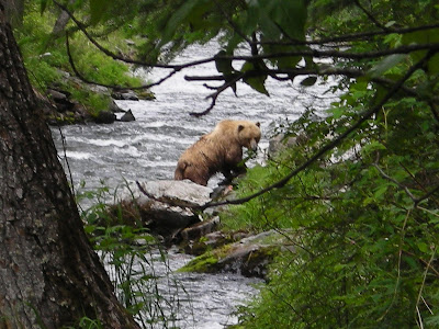
Grizzly count has been pretty low so far, but now that the salmon are here, the bears are soon to follow.

 N 60°29'04"
W 149°58'25"
Time to discuss my new backyard for the next 7 weeks or so. The Russian River Campground is wedged between the Russian River and the Kenai River (pronounced Key-nie). Most of the campsites are located on a shallow mountain top or along the ridge nestled between towering mountains that threaten to all but engulf the small campsite below. On the approach to the campsites near the back of the campground property, a narrow, bumpy road windes along the Kenai River. About half way up the road, there is a tiny island barely in the river with large birch trees growing. At the top of one of those trees is a large Bald Eagle nest where, of course, a rather large symbol of America resides.
A handle full of glimspes of bear sightings so far, mostly black bear. A couple of moose that I have seen personally, along with dozens of large rabitts that are so big that I feel as if they should be classified as Kangaroos. Anyways the salmon should be here soon and then comes the Grizzlys.


